
|
 |
In the morning, we collected a car of a type called a "Twingo" that was new to us. Very small, but serviceable for our purpose, which was to drive to Heraklion, pick up Lanny and MaryAnn North, and drive to Phaestos, perhaps 60 km from Heraklion. It was delivered practically empty of gas, a fact we did not discover until we were half-way across the island.
The road was for the most part quite good, except that it was very narrow through the villages, with sharp corners between the houses. The scenery, once again, was magnificent, with valleys filled with vines and olives between mountains that were more than Scotland and less than the Alps, as in Mainland Greece. Shortly before Phaestos, we passed a Roman site that had quite a few visitors, but we didn't stop.
 |
|
Overview
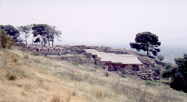
of the palace of Phaestos (image taken from the entrance ticket).
The four strips at the centre-right are roofs where archaeologists are
presently working. The open space to their left is where the old entrance
road emerges, ending in the step-like "theatre" shown in a picture
on this page. The area furthest from this viewpoint is where we saw the
Mason's Marks
carved into the stones.
|
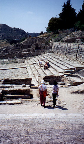
When we got to Phaestos, we found the parking lot so full of buses that we had to park on the road beyond the lot. We expected the site to be jammed solid with people, but it is big enough that we found it seemed almost empty. In the left picture below (approaching the site), you see a crowd on the space above the theatral area, but we saw no such crowd when we reached the site.
 |
 |
 |
| Phaestos. (Above) Approaching the site, one see first the roofs that cover the old part of the site, where the archaeologists are currently working. |
(Left) The
"Theatre" at the head of the old entry road; (Above) These
flowers grow wild all over. They have thick, fleshy leaves, and the
flowers close if it gets dark or rainy.
|
The palace itself seems to have been almost as extensive as Knossos, but it is much less restored, or perhaps was more decayed over time. The site is more impressive than Knossos, overlooking the valley from high, as it does. However, there may have been fewer or smaller buildings than at Knossos. Some of it has clearly fallen into the valley as the hillside has eroded, but probably not too much, as there are also some excavated Minoan ruins below at the bottom of the slope. They are part of the town associated with the palace.
 |
 |
 |
|
(Left) One of the deep storage areas for the large pithoi in which produce was kept.(Above)General view of the palace walls |
Below this cliff a few houses of the Minoan town are being excavated. |
As we wandered around the main palace part of the site (the jumble furthest from the viewpoint of the overview picture, we saw symbols cut into the rock. On this page, there is a discussion of the symbols we saw here and at Malia the next day, as well as in various museums we later visted. Often in Phaestos, we found similar symbols in the same general area, as if they referred to the area itself, perhaps referring to the purpose of the area, perhaps as direction indicators like street signs, perhaps for religious reasons. We found that these symbols cut into the stones are called "Mason's Marks", and we were told both that they were a precursor of the Linear A script, and that they were actually a variant of Linear A. Subsequent attempts to find out about them on the Web have been fruitless.
While we are dealing with writing systems, I should mention the mysterious "Phaestos Disk," the two sides of which ae shown in the thumbnails at the top of the page (click on them to get more detailed pictures). The pictures are scans of a museum replica we bought at the Athens Museum. It is a baked clay disk about 17cm in diameter, stamped with a spiral of characters that seem to form a text. One interesting thing about it is that it seems to have been stamped with the equivalent of moveable type--a set of blocks holding icons or symbols all of much the same size, which were impressed one after the other in a spiral from the edge to the centre, with the words (or are they phrases) outlined by a scribed line. Nothing like it has been found anywhere else, though one would think that if the writing system had been well enough used to make it worthwhile to construct printing blocks, there should be a lot of it somewhere. Unless, of course, it is a hoax. But it is considered a mystery rather than a hoax by those who know the archaeology, so...(More about the Phaestos Disk is here).
The Phaestos disk is seen all over Crete, especially in jewellery shops, where it appears in silver and gold, as earrings or pendants, and in souvenir shops, where it comes in a wild variety of materials and sizes.
 |
After a pleasant picnic lunch in the shade of the trees at the far side of the site in the first picture, we went to the nearby site of Agia Triada, another palatial establishment. We did not get in, because we got there a few minutes after closing, but we could see some of the ruins from outside the chain-link fence.
We were toldAgia Triada had been a place where the residents of Phaestos would go to get away from the summer heat in Phaestos, though this seems hardly credible, given the situations of the two sites. Phaestos is on a high bluff, open to the winds, whereas Agia Triada is sheltered halfway down a hillside. Perhaps it is a north-facing slope, but I don't think so, not having taken too much notice at the time. Be that as it may, Agia Triada seems to have been a similar but smaller palace complex. According to books I have read subsequently, Phaestos was more or less abandoned before Agia Triada came into its own.
 |
 |
From Agia Triada, we drove eastward along the south side highway. It is not a shore road, and one hardly ever sees the sea, if at all. But the views are quite spectacular, in spite of the weather being a bit hazy. We saw many saddled donkeys tied by the roadside, their owners presumably doing something in the olive groves. Many of the donkeys did not seem to be very well looked-after.
 |
Finally, we took what seemed at first to be a little road to nowhere. Indeed, the first time we started up it, we turned back, convinced that it was a farm track, and could not be the road we were looking for. But the map seemed to indicate it had to be the road back across the mountains to the north shore, and so it turned out to be. The scenery was interesting, but not as spectacular as on the morning crossing of the island. The road was pleasant enough, though narrow and winding, and sometimes not too well-surfaced.
Once back at the hotel, we relaxed on the terrace overlooking the sea, had dinner, and then took the Norths back to Heraklion, after a wonderful day.
To start with, we had a really clear day, for the first time since we came to Greece. But the clarity didn't last, unfortunately. As the day wore on, it got hazy, and then the clouds came down upon the mountains, and for a few moments in the afternoon we drove through cloud as we were coming down from Lassithi.
 |
 |
|
The Lychnostatis "Heimat Museum" near our
hotel. (Above) The garden and
the Byzantine Church (Right)
A curiously carved tree stump..
|
Before going to the archaeological sites, we visited an open-air museum of Cretan culture that was close to the hotel. It was called the "Lychnostatis Heimat Museum". At the entrance there was a demonstration and display herb and flower garden. On the roof there was a typical windmill, quite unlike the Dutch kind of windmill (we saw many of the same kind later in the day, in the Plateau of Lassithi). In the building there is a typical living room, and demonstration potters and weavers workshops. The left picture shows a little Byzantine church, which might hold 3 worshippers at a pinch, while the right picture shows a curously carved tree (to see the carving, you have to click on the thumbnail to see the big picture).
 |
Malia
After strolling around the Heimat Museum for half an hour or so, we went on to the nearby Minoan palace of Malia. This was the third of the four major palaces (we did not see Zakros, the fourth). Its situation is quite unlike that of the other two. They are fairly high, overlooking valleys, but Malia is right on the coastal plain. If, as they say, the Thera explosion of 1650 BC created a tsunami 250m high at Crete, it must have simply swept the tops off all the buildings on its way to, and back from, the mountain wall a couple of kilometers behind the palace (visible in the picture).
Even as the third site, Malia is pretty big, and to look at it all would take more time than we allowed. At first, it seems a big jumble of rock, but the shape of it begins to come clear after a while. As with all the Minoan palaces, there is a large central court, with small rooms off orthogonally arranged passages in what was presumably a main residential area.
The stones at Malia are of quite a different type to those at Knossos and Phaestos. Here there are two main kinds, a smooth irregular grey blocky material, and a deeply corroded red stone (sandstone?). It would be next to impossible to find any Mason's Marks on the red stone, but we found a few (about 40 different ones, in fact) on the grey stone.
We were immediately surprised at the almost complete absence of tridents among
the marks, since they had been the predominant form at Phasetos. We saw only
one, and it was a slanted trident--we saw no slanted ones in Phaestos. In Malia,
however, we saw many variants on what had been called the "labrys" form--two
triangles end-to-end with a bar at right angles to their common axis, like a
handle for a two-bladed axe. "Labrys" forms were rare in Phaestos. But I have
come to doubt the interpretation of the form as representing the labrys, for
two reasons. One is that there were so many variants, with "modulations" that
also appear on other forms, and the other is that I saw only one example on
a vertical surface where one could see its orientation, and then it looked like
this: ![]() which
does not look as one would expect a picture of an axe to look. In both palaces
there were lots of "star" variants, but Malia had none of what we
called the "Chinese tree" because it looks identical to the Chinese character
for "tree". (Here is the
page on which I discuss these Mason's Marks further).
which
does not look as one would expect a picture of an axe to look. In both palaces
there were lots of "star" variants, but Malia had none of what we
called the "Chinese tree" because it looks identical to the Chinese character
for "tree". (Here is the
page on which I discuss these Mason's Marks further).
 |
 |
|
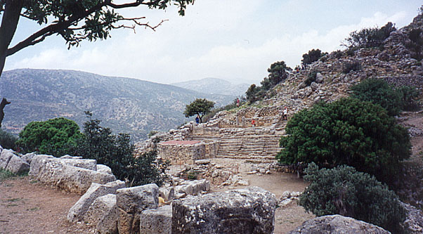
Lato: (above) the
Theatre, in the saddle between the two peaks, and some of the small
rooms that fill the north hillslope above it; (right) the south
Akropolis, showing the remains of a couple of the larger buildings.
|
From Malia, we drove further east along the coast to Agia Nikolai and then inland and uphill on a rather small road, and then a smaller road up even higher to a Dorian site called Lato. The Dorians apparently took over from the Myceneans who had taken over administration of Crete from the Minoans after the Thera explosion. From what we could gather, the Dorians had no artistic pretensions, and were interested only in war.
Whereas the Minoan palaces had no fortifications whatsoever, the Dorian sites we saw in Crete and Santorini were fortresses on high bluffs, and consisted of blocky grey stones. One got the impression of the Dorians as grim, agressive people, in contrast to the Minoan (and later Corinthian) delight in the arts and in the happiness of the people.
The site of Lato is spread out on two peaks separated by a high saddle. In the saddle there is a theatre with straight rows of seats, like the old one in Phaestos. The Lato theatre was smaller, and might have seated 100-200 people at the outside. In the middle of the orchestra (where the actors would have walked) was a deep rectangular pit cut into the rock, perhaps 10 ft on a side and 20 ft deep. Its purpose was not clear. However, here's a guess. If these "theatres" were places for formally greeting visiting parties of dignitaries (all three that we saw were by the entrances of the sites), then the pit could have been a defensive measure, a place in which to trap unwary and unwelcome visitors.
Up one hillside above the saddle were the remains of larger public buildings, including perhaps a temple, whereas on the other side, the remains were mostly of many small rooms all the way up to the peak of the hill. There were no interpretive signs, which had been a feature of most of the sites we visited, and the ruins were less intelligible than most. The characteristics of the site were very different from those of most of the other places we saw, and that hindered our understanding.